Small deposit in India. Balance in Nepal.
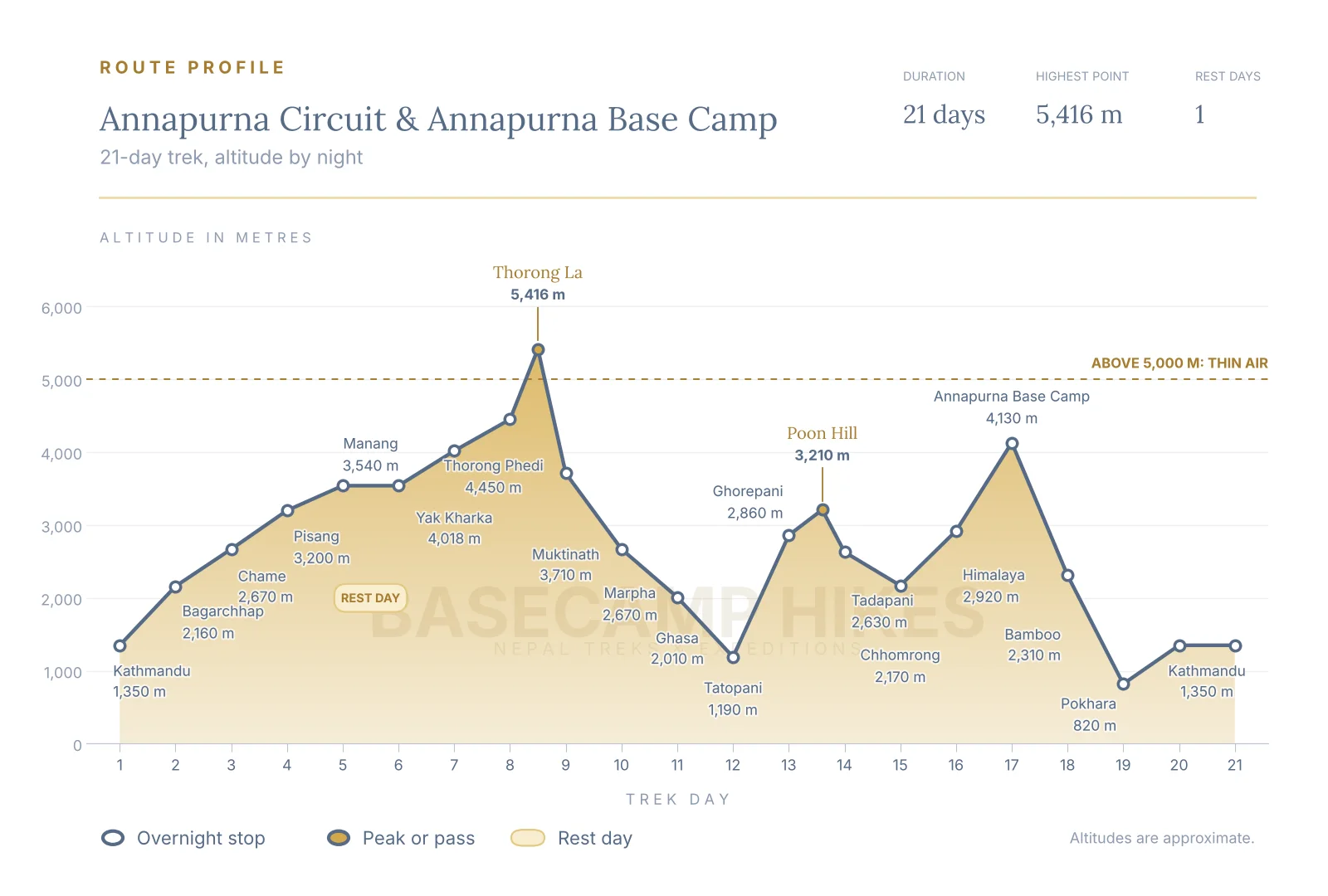
This 21-day trek joins the two great Annapurna journeys into one. You follow the Marsyangdi valley up to Manang, rest and acclimatise, cross Thorong La at about 5,416 m, and descend through the holy site of Muktinath into the dry Kali Gandaki valley. After a jeep ride to the hot springs of Tatopani you climb to Ghorepani and Poon Hill, then walk into the Annapurna Sanctuary to sleep at Annapurna Base Camp, 4,130 m, with a ring of giant peaks around you. You finish with the Jhinu hot springs and two nights in Pokhara before returning to Kathmandu.
The plan puts the pass first, while you are fresh and acclimatised, and the sanctuary second, when the altitude is lower and your legs know the rhythm of long days. Your licensed guide checks oxygen levels every day, and a rest day in Manang, a short stage to Yak Kharka and a sleep at Thorong Phedi keep the climb gradual.
Route: Airport to hotel. Sleeping height: 1,350 m. Activity: Arrival and trek briefing. Overnight: Kathmandu hotel.
Our team meets you at Tribhuvan Airport and drives you to your hotel. In the afternoon or evening your guide runs the trek briefing: route, daily timings, altitude rules, packing check and rental gear such as sleeping bags and down jackets. Use the rest of the day to exchange money, buy snacks and sleep well before the long bus day.
Route: Kathmandu to Besisahar by local bus, then by shared vehicle to Bagarchhap. Sleeping height: 2,160 m. Activity: Long travel day of about 10 to 12 hours in total. Overnight: Bagarchhap teahouse.
You leave early on a local bus along the Prithvi Highway to Besisahar, the old starting point of the circuit, then continue by shared vehicle on a rough road up the Marsyangdi valley. The valley changes from rice terraces to pine and bamboo, and you reach the Manang district at the end of the day. Journey times swing with traffic and road work, so treat the hours as a guide.
Route: Bagarchhap to Chame. Sleeping height: 2,670 m. Activity: Walk of about 4 to 5 hours. Overnight: Chame teahouse.
You climb through forest toward Timang and Danaqyu, where Annapurna II appears on a clear morning, with Manaslu visible from some spots. Chame is the district headquarters and has a small bazaar, shops and hot springs a short walk from the lodges. The air starts to feel thinner here, so keep your pace slow.
Route: Chame to Pisang. Sleeping height: 3,200 m. Activity: Walk of about 5 to 6 hours. Overnight: Pisang teahouse.
The valley opens into a wide glacial trough and the dark curve of Paungda Danda rises above the river. You pass apple orchards and a long pine forest before reaching Pisang. Your guide will talk through the first signs of altitude sickness this evening, and you will check oxygen saturation as part of the daily routine.
Route: Pisang to Manang by the upper route. Sleeping height: 3,540 m. Activity: Walk of about 6 to 7 hours. Overnight: Manang teahouse.
We take the upper trail through Ghyaru and Ngawal, which is longer than the valley road but far more scenic, with Annapurna II, III and Gangapurna ahead. Monasteries and stone villages line the route. Manang is a lively trekking town with bakeries, a rescue post and film shows in season.
Route: Rest day with a short hike. Sleeping height: 3,540 m. Activity: Climb high, sleep low. Overnight: Manang teahouse.
This is the most important day of the circuit. Walk up toward the Gangapurna lake viewpoint or the Praken Gompa trail and return to sleep in Manang. Attend the daily altitude talk at the health post if it is running. Spend the afternoon drinking fluids, washing clothes and resting your legs.
Route: Manang to Yak Kharka. Sleeping height: 4,018 m. Activity: Walk of about 4 hours. Overnight: Yak Kharka teahouse.
The trail leaves the last big village and climbs gradually to Gunsang and then Yak Kharka, a grazing area with a handful of lodges. It is a short day on purpose, giving your body time to adjust. Expect wide, dry landscapes and views of Chulu and Pisang peaks.
Route: Yak Kharka to Thorong Phedi. Sleeping height: 4,450 m. Activity: Walk of about 3 to 4 hours. Overnight: Thorong Phedi teahouse.
A steady climb beside the river brings you to Ledar and then along a short stretch above a loose slope, where we keep spacing between walkers. Phedi means the foot of the hill, and the pass looms above the lodges. Eat well, pack your daypack for tomorrow and go to bed early.
Route: Thorong Phedi to Thorong La to Muktinath. Sleeping height: 3,710 m. Activity: Walk of about 9 to 11 hours. Overnight: Muktinath teahouse.
The hardest and best day starts around 4:00 AM with headlamps. You climb about 960 m to the pass at about 5,416 m, then descend more than 1,700 m on a long, steep path toward Muktinath. We set a turnaround time with your guide, and the weather has the last word. Muktinath is a holy site for Hindus and Buddhists, so keep the evening for rest and a visit to the temple area if you have energy.
Route: Muktinath to Marpha by Kagbeni and Jomsom. Sleeping height: 2,670 m. Activity: Walk or jeep, about 5 to 8 hours. Overnight: Marpha teahouse.
You drop into the dry, windy Kali Gandaki valley, with views of Dhaulagiri and Nilgiri. Depending on your energy and the road, you can walk through Kagbeni, the river flats and Jomsom, or take a jeep for part of the way. Marpha is a tidy whitewashed village known for its apple orchards, apple brandy and narrow paved lanes.
Route: Marpha to Ghasa by Tukuche and Kalopani. Sleeping height: 2,010 m. Activity: Walk or jeep, about 4 to 7 hours. Overnight: Ghasa teahouse.
The valley turns greener as you pass Tukuche, an old trading town, and Larjung, then reach Kalopani where Annapurna I and Dhaulagiri stand on either side of the gorge. The pine forest thickens before Ghasa, a small Thakali village at the edge of the lower valley. A road runs along much of this stretch, so your guide will pick the best sections to walk.
Route: Ghasa to Tatopani by Lete and Dana. Sleeping height: 1,190 m. Activity: Walk or jeep, about 3 to 6 hours. Overnight: Tatopani teahouse.
You follow the Kali Gandaki, often described as one of the deepest gorges on Earth, past waterfalls and subtropical forest, and reach Tatopani, where natural hot springs soothe sore legs after the pass. The height change is large, so you may feel warm and sleepy.
Route: Tatopani to Ghorepani. Sleeping height: 2,860 m. Activity: Walk of about 6 to 8 hours. Overnight: Ghorepani teahouse.
A big climb, over 1,600 m of ascent, through terraced fields, Ghara and Shikha villages, and finally rhododendron forest. It is steep and tiring, so start early and walk slowly. Ghorepani sits in a saddle with views across to Dhaulagiri in the late light.
Route: Ghorepani to Poon Hill, then to Tadapani via Deurali pass. Sleeping height: 2,630 m. Activity: Pre-dawn climb, then walk of about 5 to 6 hours. Overnight: Tadapani teahouse.
Climb to Poon Hill at about 3,210 m before dawn for a sunrise over the Annapurna and Dhaulagiri ranges, then return to Ghorepani for breakfast. The day continues through Deurali pass and thick rhododendron and oak forest to Tadapani, with views of Annapurna South and Machhapuchhre on a clear day. Expect leeches only in the monsoon months, mud after rain and plenty of steps.
Route: Tadapani to Chhomrong. Sleeping height: 2,170 m. Activity: Walk of about 5 to 6 hours. Overnight: Chhomrong teahouse.
You descend through forest to Chuile and cross a suspension bridge, then climb stone steps to Chhomrong, a Gurung village on a steep slope. The view of Annapurna South and Machhapuchhre is clear on a good evening. This is the last place with a good range of shops before the sanctuary.
Route: Chhomrong to Himalaya by Sinuwa and Dovan. Sleeping height: 2,920 m. Activity: Walk of about 6 to 7 hours. Overnight: Himalaya teahouse.
The trail goes down to the Chhomrong Khola, then climbs through Sinuwa, bamboo forest and Dovan along the Modi Khola gorge. The path is up and down, and rain or snow can make the steps slippery. The lodge at Himalaya sits in the forest at the entrance to the high sanctuary.
Route: Himalaya to Annapurna Base Camp via Deurali and Machhapuchhre Base Camp. Sleeping height: 4,130 m. Activity: Walk of about 6 to 7 hours. Overnight: Annapurna Base Camp lodge.
The valley narrows, then opens into a vast amphitheatre ringed by Annapurna I, Annapurna South, Gangapurna and Machhapuchhre. Avalanche risk is checked each day, and in snow your guide may change the schedule. Arrive in time for sunset on the walls above the lodge. It will be very cold at night.
Route: Annapurna Base Camp to Bamboo. Sleeping height: 2,310 m. Activity: Walk of about 7 to 8 hours. Overnight: Bamboo teahouse.
After a sunrise view you retrace the route down through Deurali, Himalaya and Dovan to Bamboo. This is a big descent of more than 1,800 m, hard on the knees, so poles help. Rest and drink well; the air is thick and warm after a night at base camp.
Route: Bamboo to Jhinu to Nayapul, then by road to Pokhara. Sleeping height: 820 m. Activity: Walk of about 6 to 8 hours (less if you ride a jeep for part), then a drive of 1.5 to 2 hours. Overnight: Pokhara hotel.
Climb to Sinuwa, then drop to Jhinu where hot springs beside the river are an optional stop.The final section follows the lower valley to Nayapul, or to a point where a jeep road takes over. A vehicle then carries you to Pokhara, where you reach a hot shower and a real bed. Your guide will confirm where the walk ends on the day.
Route: Pokhara to Kathmandu by flight. Sleeping height: 1,350 m. Activity: Flight of about 25 minutes. Overnight: Kathmandu hotel.
Take the short morning flight to Kathmandu, with mountain views on a clear day if the weather allows. Flights can be delayed or cancelled in poor weather, so keep the day flexible. The afternoon is free for last-minute shopping, a farewell dinner and packing.
Route: Hotel to airport. Sleeping height: 1,350 m. Activity: Departure.
Our team drops you at Tribhuvan Airport for your onward flight. If your flight leaves late, ask us about a late check-out.

Before you pay a deposit for your Nepal trek, read our booking terms and conditions. They explain what your trek price covers, which costs are extra, and what happens if flights are delayed or your plans change.
These are the sections trekkers check most often:
Not sure about something? Call or WhatsApp us on +91 932 595 1234, or send us a message. We will explain any term before you book.
It joins two classic Annapurna treks into one journey. You walk the Marsyangdi valley to Manang, cross Thorong La at about 5,416 m, descend to Muktinath, follow the Kali Gandaki gorge through Marpha and Ghasa to Tatopani, then climb to Ghorepani and Poon Hill before trekking into the Annapurna Sanctuary to Annapurna Base Camp at 4,130 m. You finish in Pokhara and fly back to Kathmandu.
Both treks give you something different. The circuit offers dry high-desert scenery, Manang and the big pass, while the sanctuary is a close-up bowl of ice and rock. Doing both in one trip saves the cost and time of two separate journeys and lets you use the acclimatisation you already earned on the circuit.
The 18-day circuit finishes after Muktinath and Jomsom, and the standalone Annapurna Base Camp trek starts and ends around Pokhara. This 21-day route is a continuous combination of the two, joined by the walk or jeep ride down the Kali Gandaki through Marpha and Ghasa to Tatopani and the climb to Ghorepani. Our Annapurna Circuit and our Annapurna Base Camp pages show the single-trek options.
Walking up the Marsyangdi valley and crossing Thorong La from Manang gives you a gradual climb, a rest day in Manang and a pass crossing from the east. The reverse route climbs to the pass much faster from Muktinath and gives poorer acclimatisation. Most operators and guides therefore prefer this direction.
Thorong La at about 5,416 m is the highest point, and Annapurna Base Camp at 4,130 m is the highest overnight stop in the sanctuary. Thorong Phedi, where you sleep before the pass, is 4,450 m. Heights vary a little between maps and GPS devices, so treat the numbers as close guides.
Day 1 Kathmandu, Day 2 bus to Besisahar and shared vehicle to Bagarchhap, Day 3 Chame, Day 4 Pisang, Day 5 Manang, Day 6 rest in Manang, Day 7 Yak Kharka, Day 8 Thorong Phedi, Day 9 Thorong La to Muktinath, Day 10 Marpha, Day 11 Ghasa, Day 12 Tatopani, Day 13 Ghorepani, Day 14 Poon Hill sunrise and Tadapani, Day 15 Chhomrong, Day 16 Himalaya, Day 17 Annapurna Base Camp, Day 18 Bamboo, Day 19 Jhinu, Nayapul and Pokhara, Day 20 flight to Kathmandu, Day 21 departure.
It keeps the price low and puts you on the trail without a private-vehicle surcharge. The journey is long, with about 10 to 12 hours from Kathmandu to Bagarchhap in total, and the seats are shared, so bring a light jacket, snacks, water and patience. If you prefer a private jeep for comfort, ask us for a quote.
Roads now follow much of the Marsyangdi and Kali Gandaki valleys, so some sections are dusty and busy with jeeps. This trip starts with a local bus and shared vehicle to save the road walking, and on the Kali Gandaki side you can walk or ride between Muktinath, Marpha, Ghasa and Tatopani. We walk the sections that are still real paths, such as the Pisang upper route, Ghyaru and Ngawal. Your guide will tell you the best choice on the day.
It is the hardest day of the trek. You leave Thorong Phedi around 4:00 AM, climb about 960 m in 4 to 5 hours, then descend over 1,700 m to Muktinath, for a total of 9 to 11 hours. The path is clear but long and cold, with thin air. You need steady fitness, warm layers and a slow, patient pace, not technical skills.
Your guide checks conditions at Thorong Phedi and decides on the morning of the crossing. In bad weather you wait a day, and if the pass stays unsafe you may need to change the plan. Heavy snow in 2014 showed that mountain weather can turn quickly. Keep a day or two free in your calendar around this trek.
We use Thorong Phedi at 4,450 m, because a lower sleeping height gives you better acclimatisation, even though the pass day is longer. High Camp sleeps about 400 m higher and shortens the climb, but many people sleep poorly there. If you are sick or sleeping badly at Phedi, you should not go higher.
Not usually in the main spring and autumn seasons, but the pass can have ice, particularly in the early morning and in the colder months. Your guide will tell you if lightweight microspikes are worth carrying, and we can help you find rental options in Kathmandu or Manang. Trekking poles are strongly advised for the long descent.
Yes, when you follow the plan. You walk in a group with a guide and a headlamp, there is a clear path and other trekkers are on the trail, and you turn around if you are not near the pass by the agreed time. The start is early because winds and clouds are normally worse later in the morning.
From Chhomrong you descend and climb through Sinuwa, bamboo forest, Dovan and Himalaya, then climb above the tree line to Deurali, Machhapuchhre Base Camp and Annapurna Base Camp. It has long staircases and steep ascent, but the payoff is a sunrise or sunset with Annapurna I and Machhapuchhre all around you.
There can be, especially after fresh snow and in the colder months, so the guide checks the weather and slope conditions every day. If conditions are unsafe, we may stop at Machhapuchhre Base Camp or change the timing. Spring and autumn are the safest, with winter and monsoon needing extra care.
Yes. The sunrise from Poon Hill at about 3,210 m is one of the most photographed in Nepal, with Dhaulagiri and the Annapurna range lit up in the first light. It also fits naturally between Tatopani and Tadapani, and in this itinerary you climb it before breakfast and then walk on to Tadapani the same day. It is a pre-dawn climb of about an hour with plenty of other trekkers, and you can skip it if you are tired.
They are simple, natural pools by the river with an entry fee, a place to soak and rest your legs. Tatopani is a longer stop after the pass, and Jhinu is on the final day from Bamboo. Opening hours and charges vary, so bring a swimsuit and small cash.
You climb slowly above 3,000 m, take a rest day in Manang with a climb-high-sleep-low walk, and sleep at Yak Kharka and Thorong Phedi before the pass. After Muktinath you go down to Tatopani, so the Annapurna Base Camp section is another gentle build up. Your guide checks your oxygen saturation every day and can stop or turn you around.
You should be able to walk 5 to 8 hours a day for many days in a row with a daypack. This is a demanding trip because it is long and includes a big pass, a steep climb from Tatopani and many stone steps. Train for about three months with hill walks and stair climbs.
March to May and October to November are the most reliable seasons, with clear mornings and stable trails. October and November have the best views, while spring has rhododendron blossom and warmer nights. December to February can be very cold and snowy, and the monsoon brings rain and leeches in the lower areas.
It is possible but not ideal. In winter Thorong La can be blocked by snow and the sanctuary needs avalanche care, and in the monsoon landslides and rain affect the lower sections, although the Manang and Mustang side is drier. Ask us for current conditions before you plan outside spring or autumn.
You need an Annapurna Conservation Area entry permit and trekker registration, and we arrange both for you. Fees and the registration system change from time to time, so we confirm the current rules at booking. Bring your passport and passport photographs, and Indian guests should carry the identity document they plan to use.
Airport transfers, two nights in a Kathmandu hotel and one in Pokhara with breakfast, the local bus and shared vehicles on the road sections, the flight from Pokhara to Kathmandu, 17 nights in teahouses on twin sharing, three meals a day on the trail, a guide, one porter for every two trekkers, permits, taxes and a trek briefing. The package page lists everything in full.
International flights, visa, insurance, personal gear, drinks and snacks outside the meal plan, hot showers, device charging, Wi-Fi, tips, entry fees in the cities, extra days caused by weather or delays, oxygen cylinders and rescue costs. Lunch and dinner in Kathmandu and Pokhara are also yours to pay.
A good rule is USD 350 to 500 (INR 30,000 to 45,000) for the 17 days on the trail. Bottled water, charging, hot showers, Wi-Fi and snacks cost more as you go higher, and tipping about 10% is usual. Cash is best, and an ATM may not work above Manang.
Yes, you can rent them in Kathmandu at the briefing for a small daily fee. A warm four-season sleeping bag is useful for the nights above 4,000 m, and a down jacket is important on the pass and at Annapurna Base Camp.
Signal and Wi-Fi are available in larger villages such as Chame, Manang and Jomsom, but they are slow and can stop working. Charging costs extra in many lodges. Bring a power bank and keep your phone warm, as batteries run down fast in the cold.
Rooms on the trail are twin sharing, so there is no single room charge for the teahouses. If you travel alone, you may share or pay extra for a private room where lodges have enough rooms, and hotel nights in the cities can be booked as single rooms for an extra charge.
Insurance is mandatory and we ask for proof before you arrive. It must cover trekking to at least 5,500 m and emergency helicopter evacuation. Many standard policies stop at 4,000 m, so check the altitude clause before you buy.
Your guide raises the alarm and our Kathmandu team arranges the helicopter with your insurer. The cost can pass USD 5,000, and you claim it back from your insurance. Rescue is never delayed over payment.
Himalayan Wonders Adventure Pvt. Ltd., our licensed operator in Nepal, employs your guide and porters. You can meet the team on our team page.
A deposit secures your place and the balance is due when you reach our Kathmandu office. Indian guests send the deposit by bank transfer or UPI, and guests abroad may use a transfer or an online card (a 4.5% fee applies). Cash saves you the 13% charged on cards in Nepal.
For the first 30 days half of it can be refunded. After that it is not refundable, but it stays valid for a year on any trek or climb we run. A no-show without contact forfeits it.
Very. You can move your departure as often as you like at no charge if you give 6 weeks' notice. With 2 to 6 weeks' notice a fee of INR 5,000 (Indian guests) or USD 100 (other guests) applies, and changes are not possible with less than 14 days' notice. If the new date costs more, you pay the difference.
No. Our staff and bookings are paid for the whole schedule, so unused days are not refunded. We will help you get home, and any extra hotel, meals or flights are yours to pay. Your insurer may cover some of it.
Tell us your group, your dates and your budget. We will shape this trek around you.


