By
The Annapurna Circuit is a teahouse trek that crosses the Thorong La pass at 5,416 m and takes you from subtropical river valleys, through the dry Manang plateau, to the Kali Gandaki gorge, one of the deepest in the world. This guide sets out the 18-day schedule day by day, with altitudes, distances and walking times, plus the permits, season, packing and fitness advice that go with it.
The short answer
- Length: 18 days from arrival to departure in Kathmandu, with 14 trekking days.
- High point: Thorong La, 5,416 m (17,800 ft), crossed on Day 11 from Thorong Phedi to Muktinath.
- Rest day: one, at Manang (Day 8).
- Route: Besisahar to Muktinath over the pass, then down the Kali Gandaki to Tatopani, Ghorepani, Poon Hill and Pokhara.
- Difficulty: strenuous but not technical. The pass day is long and cold.
Last checked: 26 October 2026. Roads, fees and trail conditions on this route change, so confirm them for your dates.

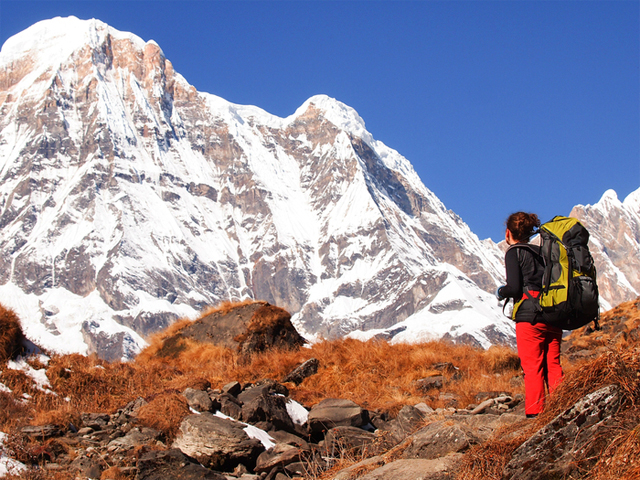
Walking in the high Marsyangdi valley, where the peaks of the Annapurna range come into view.
In this guide: At a glance | Altitude profile | Day-by-day itinerary | Permits | Best season | Fitness and packing | FAQ
Annapurna Circuit at a glance
| Region | Annapurna Conservation Area: Lamjung, Manang, Mustang and Myagdi |
| Highest point | Thorong La, 5,416 m / 17,800 ft |
| Highest sleeping altitude | Thorong Phedi, 4,450 m / 14,600 ft |
| Length | 18 days, with 14 trekking days |
| Rest day | 1 (Manang) |
| Start and finish | Besisahar (by road) and Nayapul, then Pokhara |
| Lodging | Twin-share teahouses on the trail, hotels in Kathmandu and Pokhara |
| Difficulty | Strenuous, no technical climbing |
| Group size | 1 to 10 trekkers |
Altitude profile: where you sleep
Sleeping altitudes on the 18-day schedule. The blue bar is the rest day and the grey bars are the descent.
| Night | Sleeping altitude | Profile |
|---|---|---|
| Day 2 Besisahar | 820 m / 2,690 ft |
|
| Day 3 Chamje | 1,385 m / 4,544 ft |
|
| Day 4 Bagarchhap | 2,160 m / 7,087 ft |
|
| Day 5 Chame | 2,710 m / 8,891 ft |
|
| Day 6 Pisang | 3,250 m / 10,663 ft |
|
| Day 7 Manang | 3,540 m / 11,614 ft |
|
| Day 8 Manang (rest) | 3,540 m / 11,614 ft |
|
| Day 9 Yak Kharka | 4,050 m / 13,287 ft |
|
| Day 10 Thorong Phedi | 4,450 m / 14,600 ft |
|
| Day 11 Muktinath | 3,800 m / 12,467 ft |
|
| Day 12 Marpha | 2,670 m / 8,760 ft |
|
| Day 13 Ghasa | 2,010 m / 6,594 ft |
|
| Day 14 Tatopani | 1,200 m / 3,937 ft |
|
| Day 15 Ghorepani | 2,870 m / 9,416 ft |
|
| Day 16 Pokhara | 827 m / 2,713 ft |
|
Above 2,500 m the Nepal Tourism Board (NTB) advises a rise in sleeping altitude of no more than 300 to 500 m a day. On this schedule the largest steps above 3,000 m are Chame to Pisang (about 540 m) and Manang to Yak Kharka (about 510 m), both slightly over the guide, and Yak Kharka to Thorong Phedi adds about 400 m. The rest day at Manang before the last climb, and the short walking days that follow, are what keep the crossing manageable.
Day-by-day itinerary
All distances and times are approximate. Road works, weather and lodge space can change a day.
Day 1: Arrive in Kathmandu
| Altitude | 1,350 m / 4,428 ft |
| Overnight | Kathmandu hotel |
A team member meets you at the airport and takes you to your hotel. In the evening the team briefs you on the route, checks your gear and answers last questions. Rent a sleeping bag or down jacket now if you need one, because the nights above Manang are cold.
Day 2: Drive from Kathmandu to Besisahar
| Altitude | 820 m / 2,700 ft |
| Travel | Drive of 7 to 10 hours |
| Overnight | Besisahar |
A long day on the road follows the river valleys west of Kathmandu to Besisahar, the district town where the circuit begins. The first snow peaks appear near the end of the drive. Traffic and road works decide the exact timing, so start early.
Day 3: Besisahar to Chamje
| Altitude | 1,385 m / 4,540 ft |
| Distance | 8 km / 5 mi |
| Travel | 1 hour by road to Syange, then 5 to 6 hours on foot |
| Overnight | Chamje |
A short drive takes you to Syange, where the walking starts. The trail passes a waterfall and crosses the Marsyangdi on a suspension bridge, then climbs through Jagat to Chamje, a small village in a steep green valley.
Day 4: Chamje to Bagarchhap
| Altitude | 2,160 m / 7,087 ft |
| Distance | 15 km / 9 mi |
| Walking | 6 to 8 hours |
| Overnight | Bagarchhap |

Green valleys below the peaks on the lower half of the circuit.
This is a long day, and the valley becomes narrower. You reach Tal, the first village of Manang district, then continue past Tibetan-style chortens and apple orchards. The culture changes from here, as Buddhist influence becomes stronger with every village.
Day 5: Bagarchhap to Chame
| Altitude | 2,710 m / 7,090 ft |
| Distance | 13 km / 8 mi |
| Walking | 5 to 6 hours |
| Overnight | Chame |
The trail goes through Tyanja and Kopar to Chame, the district headquarters of Manang. Annapurna II shows itself on the way, and Chame has hot springs that are welcome after a long walk.
Day 6: Chame to Pisang
| Altitude | 3,250 m / 10,660 ft |
| Distance | 13 km / 8 mi |
| Walking | 5 to 6 hours |
| Overnight | Pisang |
You walk through forest and along a steep-sided valley, with the great curved rock face of Paungda Danda rising above the river. Pisang is the first night above 3,000 m, so walk slowly and drink plenty of water.
Day 7: Pisang to Manang
| Altitude | 3,540 m / 11,600 ft |
| Distance | 15 km / 9 mi |
| Walking | 6 to 7 hours |
| Overnight | Manang |
The scenery turns dry and open in upper Manang, a high valley where yak herding is the way of life. There are two routes to Manang, one through Hongde and one through Ghyaru, and the guide picks the better one for the day.
Day 8: Rest and acclimatisation at Manang
| Altitude | 3,540 m / 11,600 ft |
| Overnight | Manang |

Mantra stones mark the trail through Manang.
This day is for rest. Take a short walk around the village, then come back down to sleep, which is the standard way to adapt. Wash clothes, repack and eat well, because the next three days are the hardest of the trek. Ask your guide about the signs of altitude sickness before you leave Manang.
Day 9: Manang to Yak Kharka
| Altitude | 4,050 m / 13,290 ft |
| Distance | 10 km / 6 mi |
| Walking | 3 to 4 hours |
| Overnight | Yak Kharka |
The day is short, but the climb is steady, about 500 m in all. The route passes Tenki Manang and follows the Jarsang Khola valley, where yaks graze the high pasture. Arrive early, rest and keep drinking.
Day 10: Yak Kharka to Thorong Phedi
| Altitude | 4,450 m / 14,600 ft |
| Distance | 9 km / 5.5 mi |
| Walking | 3 to 4 hours |
| Overnight | Thorong Phedi |
Another short day, with a river crossing on the way. Thorong Phedi is the base of the pass, and its guesthouses are among the newest on the route. Go to bed early, because Day 11 starts in the dark.
Day 11: Over Thorong La to Muktinath
| Altitude | Thorong La 5,416 m / 17,800 ft, Muktinath 3,800 m / 12,460 ft |
| Distance | 16 km / 9.5 mi |
| Walking | 7 to 8 hours |
| Overnight | Muktinath |
Pass day: the team starts at about 4 am to reach Thorong La before 10 am, because the wind rises later in the day. It is cold and the air is thin, so tell your guide at once if you feel unwell. For more, see crossing Thorong La.
After a long climb in the dark you reach the pass, marked with prayer flags, and then a steep and knee-testing descent takes you to Muktinath, a temple town sacred to both Hindus and Buddhists. Many pilgrims come here. Read about the Muktinath pilgrim route.
Day 12: Muktinath to Marpha
| Altitude | 2,670 m / 8,760 ft |
| Distance | 15 km / 9 mi |
| Walking | 6 to 7 hours |
| Overnight | Marpha |
The trail drops through Jhong and Kagbeni, taking a quieter path through a dry landscape with distinctive local houses and an old gompa. Marpha is known for its fruit and its water canals, and the valley wind is strong in the afternoon.
Day 13: Marpha to Ghasa
| Altitude | 2,010 m / 6,600 ft |
| Distance | 20 km / 12 mi |
| Walking | 8 to 10 hours |
| Overnight | Ghasa |
This is the longest walking day on the schedule. It passes a large gompa and Thakali settlements, and the terrain gets greener and warmer as you drop down the Kali Gandaki gorge. Some stretches of the valley now have road, so ask the team about the road and jeep sections.
Day 14: Ghasa to Tatopani
| Altitude | 1,200 m / 3,940 ft |
| Distance | 20 km / 12 mi |
| Walking | 7 to 8 hours |
| Overnight | Tatopani |
You walk through Thakali and Tamang villages and lush greenery. The name Tatopani means “hot water”, and the hot springs are the reward at the end of the day.
Day 15: Tatopani to Ghorepani
| Altitude | 2,870 m / 9,410 ft |
| Distance | 15 km / 9 mi |
| Walking | 7 to 8 hours |
| Overnight | Ghorepani |

Pokhara, the finishing town, seen from Sarangkot Hill.
A tough climb takes you out of the gorge through Shikha to Ghorepani, a busy trekkers’ stop. This is the last big ascent of the trek.
Day 16: Poon Hill, then Nayapul and Pokhara
| Altitude | Poon Hill 3,200 m / 10,500 ft; Pokhara about 827 m / 2,713 ft |
| Distance | 15 km / 9 mi |
| Walking | 6 to 7 hours, then about 1 hour by taxi |
| Overnight | Pokhara |
An early climb to Poon Hill gives a sunrise over Dhaulagiri and the Annapurna range. After breakfast the trail descends to Nayapul, where the trek ends, and a taxi takes you to Pokhara for the night. Pokhara is far lower than the trail, so the air feels thick and warm after the descent. Its city limits run from 827 m in the south to 1,740 m in the north, and the lakeside valley sits near the lower end. Read about the Poon Hill trek if you are short of time.
Day 17: Pokhara to Kathmandu
| Travel | Tourist bus, 6 to 8 hours |
| Altitude | Pokhara about 827 m / 2,713 ft, Kathmandu 1,350 m / 4,428 ft |
| Overnight | Kathmandu hotel |
The tourist bus returns to Kathmandu in the afternoon. In the evening the team hosts a farewell dinner and asks for your feedback.
Day 18: Departure from Kathmandu
A team member takes you to Tribhuvan International Airport in good time for your flight home, and the service ends there.
Permits and fees
The package includes the permits. The fees below are the Nepal Tourism Board (NTB) figures for reference, and the team confirms them at booking.
| Permit | Foreigners | SAARC nationals |
|---|---|---|
| Annapurna Conservation Area entry | NPR 3,000 | NPR 1,000 |
| TIMS card | NPR 2,000 | NPR 1,000 |
Children under 10 enter free. NTB also states that, under rules effective 31 March 2023, trekkers on the Annapurna Circuit must be accompanied by a licensed trekking guide and carry an agency-issued TIMS card. See the Annapurna permits guide.
Best time to trek
NTB lists March to May and September to November as the best seasons. Autumn is the busiest, with clear skies and steady trails. Spring brings rhododendrons and warmer days. Winter brings snow on the pass and very cold nights, and the monsoon brings rain and landslides on the lower trail, so both are less pleasant. The circuit is also walked in December and February, but the pass may be closed by snow, so ask the team first.
Fitness, packing and practical tips
- Fitness. Train with long, hilly walks carrying a daypack, for at least 8 weeks before you leave. See the training guide, which applies here too.
- Layers. Pack for subtropical heat at the start and snow at the pass: a down jacket, warm hat, gloves and a windproof shell.
- Boots. Wear boots that are already broken in. New boots cause blisters on the long descent.
- Cash. Carry Nepali rupees. Cards and machines are rare beyond the main towns.
- Altitude. Follow the schedule, drink plenty of water and never ascend with symptoms. Tell your guide at once if you feel unwell.
- Flexibility. Keep a spare day before your flight home, in case snow, landslides or road works hold you up.
- Insurance. It is mandatory, and it must cover trekking up to 6,000 m and helicopter evacuation.
FAQ
How many days is the Annapurna Circuit? The schedule here is 18 days from arrival in Kathmandu to departure, with 14 trekking days and one rest day.
How high is Thorong La? The pass is 5,416 m (17,800 ft), crossed on Day 11. The highest night is Thorong Phedi at 4,450 m.
How difficult is the Annapurna Circuit? It is strenuous but not technical. The pass day is 7 to 8 hours, and Day 13 is the longest walk at 8 to 10 hours.
Where does the trek start? By road at Besisahar, with the walking starting at Syange on Day 3. It ends at Nayapul, with a taxi to Pokhara.
Where is the rest day? At Manang on Day 8, before the climb to Yak Kharka and Thorong Phedi.
What is the best time to go? March to May and September to November, according to NTB.
Do I need a guide? NTB states that trekkers on the Annapurna Circuit must be accompanied by a licensed guide and carry an agency-issued TIMS card.
Which permits do I need? An Annapurna Conservation Area entry permit and a TIMS card, both included in the package.
What time do you cross Thorong La? The team starts at about 4 am to reach the pass before 10 am, as the wind picks up later in the day.
Are there teahouses all the way? Yes. The route has twin-share lodges every night, and the package uses them, with hotels in Kathmandu and Pokhara.
Can I do a shorter trek? Yes. See the Annapurna trekking options and the Poon Hill trek.
How does it compare with Manaslu? See Manaslu Circuit vs Annapurna Circuit.
Book the 18-day trek
For dates and a quote, see the 18-day Annapurna Circuit trek, message the team on WhatsApp or phone at +91 932 595 1234 (9 am to 7 pm IST), write to info@basecamphikes.com, or use the enquiry form.
Sources
- Nepal Tourism Board: park entry fees
- Nepal Tourism Board: Annapurna Conservation Area
- Nepal Tourism Board: TIMS card
- Pokhara Metropolitan City: city profile (altitude range 827 m to 1,740 m)