 By
Everest Base Camp weather changes with the season, and above all with altitude. The valley is warm and green at Lukla and bitterly cold at Gorak Shep, and the monsoon months bring cloud that hides the peaks. This guide explains the seasons, a month-by-month view, how temperature drops as you climb, and what winds, clouds and a changing climate mean for trekkers and climbers.
The short answer
- Best seasons: October to November for the clearest views, and March to May for warmer days and flowers.
- Monsoon: June to September. The Nepal Tourism Board (NTB) says about 80% of Nepal’s yearly rain falls then.
- Winter: December to February is the coldest, with quiet trails and bright sun on clear days.
- Temperature rule: NTB says average temperature drops about 6°C for every 1,000 m you climb.
- Summit climbing: the high winds ease in May, which is why expeditions concentrate there.
Last checked: 26 October 2026. Weather is variable, so keep a spare day in any season.

The Himalaya holds one of the largest stores of ice outside the polar regions, so it is often called the third pole.
In this guide: Seasons | Month by month | Temperature by altitude | Monsoon | Wind and summit | Clouds | Weather stations | Climate change | What to pack | FAQ
The four seasons at Everest Base Camp
| Season | Months | What it is like | Suits |
|---|---|---|---|
| Autumn | Late September to November | Clear, settled days and the best views, especially in October and early November. Nights get colder in November above 4,500 m. The busiest season, and lodges fill early | First-timers who want the clearest mountains |
| Winter | December to February | The coldest period, with a southward-shifted jet stream bringing wind and, occasionally, snow. Bright sun on clear days, and the quietest trails | Experienced trekkers with warm gear and a flexible plan |
| Spring | March to May | Slightly warmer than autumn, with rhododendrons on the lower trail, usually in April. Haze and afternoon cloud increase later. Expedition teams are at Base Camp in April and May | Trekkers who want warmth, flowers and a lively Base Camp |
| Monsoon | June to September | Frequent rain and cloud that hide the peaks, with disrupted flights and slippery lower trails | Rarely recommended for the Base Camp trek |
Everest sits at about 28 degrees north, and its weather follows the usual northern pattern, with the monsoon arriving from the south in summer. The Himalaya also blocks the cold winter winds from Central Asia, according to NTB, and forms the northern edge of the monsoon rain zone.
Month by month
| Month | What to expect |
|---|---|
| January and February | Coldest conditions, quiet trails, clear spells and the chance of snow |
| March | First rhododendrons on the lower trail, fewer people early in the month, and still cold at height |
| April | Warmest spring weather and the best forest colours, with afternoon haze softening far views |
| May | Warm, with Base Camp busy with expeditions and more haze. The monsoon can begin late in the month in some years |
| June to September | Monsoon: rain, cloud and disrupted flights. Early September can still be wet on the lower trail |
| October | The classic clear-sky month, with the busiest trails and rooms that fill fast |
| November | Often exceptionally clear, with colder nights above 4,500 m and a quieter second half |
| December | The start of the cold season, with clear days and freezing nights |
See the best time guide for more, the temperatures guide and the winter guide.
How temperature changes with altitude
NTB states that average temperatures in Nepal drop about 6°C for every 1,000 m of altitude. The table applies that rule of thumb to the places where trekkers sleep, compared with Kathmandu at the same time of year. It is an average, and wind, cloud and the hour of day change what you actually feel.
| Place | Altitude | Compared with Kathmandu |
|---|---|---|
| Kathmandu | 1,350 m | Baseline |
| Namche Bazaar | 3,440 m | About 13°C colder |
| Deboche | 3,700 m | About 14°C colder |
| Dingboche | 4,400 m | About 18°C colder |
| Lobuche | 4,900 m | About 21°C colder |
| Gorak Shep | 5,180 m | About 23°C colder |
| Everest Base Camp | 5,364 m | About 24°C colder |
By Gorak Shep, the same day is roughly 23°C colder than in Kathmandu, which is why nights above Dingboche need a very warm sleeping bag.
Rain, snow and the monsoon
NTB says roughly 80% of Nepal’s yearly rain falls from June to September. Northern valleys such as Manang and Mustang sit in a rain shadow and stay dry, but the Everest region is a different valley system, and in the monsoon months rain and cloud usually hide the peaks. The start and end of the monsoon vary from year to year, so trekkers planning for early June or late September should watch the forecast and keep spare days. See the monsoon guide and the heavy snow guide.

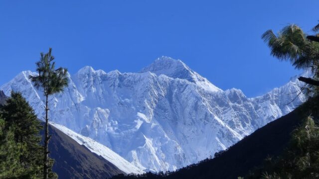
Summit temperatures follow the seasons, with the coldest period in winter.
Wind and the summit
The summit may be the windiest place on Earth. In winter the jet stream, a fast river of air high in the sky, shifts south and sits over Everest, and the winds can be fierce and the cold severe, with wind chill far below the air temperature. In the spring the jet stream moves north, and the winds ease in May. That short calmer period, with warmer summit temperatures, is the main climbing window for expeditions. The Italian National Research Council reports a station on the South Col at 8,000 m, installed in May 2011, built to work in winds and in temperatures below minus 60°C. Its first reading, on 19 May 2011, was minus 17.3°C with a wind of 9 m/s.

Upper-level winds over the Himalaya, strong in winter and weaker in summer as the jet stream moves north.
Banner clouds
On days that are otherwise clear, a long plume of cloud can stream from the summit. It is called a banner cloud, and it forms when strong wind wraps around a pointed peak and creates a pocket of low pressure on the sheltered side that draws moisture upward. The Matterhorn in Switzerland makes the same kind of cloud. A long, straight plume suggests strong wind at the summit, which is useful information for climbers.

A banner cloud on the sheltered side of the Matterhorn.
Weather stations in the Khumbu
The Pyramid observatory, set up by the Italian National Research Council near Lobuche, stands at 5,079 m and has measured weather, ozone and airborne particles since 2006. Climbing teams combine ground observations like these with large-scale weather models, and many hire forecasters for daily summit forecasts. As a rule of thumb, the temperature falls steadily with height, at the rate NTB gives above.

The Pyramid observatory near Lobuche, at 5,079 m.
Climate change and the Khumbu
The glaciers of the Everest region are changing. Scientists track both retreat and thinning, and repeat photographs taken from the same viewpoint decades apart are a simple way to see change. The pair below shows the Khumbu Glacier in 1955 and in 2007, and the Mountain Institute’s Alton C. Byers, who took the later photograph, kindly allowed its use here. A small museum at the Everest View Point in Namche Bazaar also holds historical photographs of the glacier.

1955 photograph by Erwin Schneider and 2007 photograph by Alton C. Byers.
What to pack for the weather
- Layers. Daytime on the trail can be warm and the evenings freezing, so layering works better than one heavy coat.
- Sleeping bag and down jacket. Needed in every season above Dingboche, and in winter lower down too.
- Rain gear. A waterproof shell for the shoulder weeks and for any unseasonal weather.
- Sun protection. Strong sun and snow glare call for sunglasses, a hat and high-factor sunscreen.
- Winter extras. Windproof trousers, gaiters and microspikes if snow has fallen.
- A spare day. Lukla flights are weather-dependent in every season. Mornings are usually better than afternoons.
See the packing list and the Lukla delay plan.
FAQ
What is the best month for Everest Base Camp? October gives the clearest skies, and April gives the warmest days and the best forest colour.
When is the monsoon? June to September, according to NTB. Start and end dates vary by year.
How cold is Everest Base Camp? Much colder than Kathmandu. NTB’s rule of about 6°C per 1,000 m puts it roughly 24°C colder at Base Camp altitude, before wind and the hour of day.
Is it too cold to trek in winter? It is possible. NTB notes bright sun and clear views in December and January, but nights are very cold, and snow can arrive, so winter suits experienced trekkers.
Does it rain at Everest Base Camp? Mostly in the monsoon, when rain and cloud hide the peaks. The rest of the year is much drier.
Can I see Everest in the monsoon? Rarely. Cloud usually covers the peaks.
Why do climbers go in May? The jet-stream winds ease and temperatures rise, which makes a short summit window.
Is the summit the windiest place on Earth? It is often described that way. Winter winds are the strongest.
What is the banner cloud? A plume of cloud streaming from the summit on a clear day, formed by wind wrapping around the peak.
Where is the nearest weather station? The Pyramid observatory near Lobuche, at 5,079 m.
Are the Khumbu glaciers changing? Yes. Scientists track both retreat and thinning.
Will the weather delay my flight? It can. Lukla flights depend on cloud and wind, so keep a spare day.
Plan your trek around the weather
For dates and a quote, see the 14-day Everest Base Camp trek, read the day-by-day itinerary, or message the team on WhatsApp or phone at +91 932 595 1234 (9 am to 7 pm IST), write to info@basecamphikes.com, or use the enquiry form.
Sources
- Nepal Tourism Board: climate in Nepal
- Italian National Research Council: Everest Pyramid station
- Italian National Research Council: South Col weather station