 By
This Everest Base Camp trek itinerary gives the 14-day schedule day by day, with altitudes, distances and walking times, plus the permits, best seasons, packing and cash tips that go with it. The route follows the Dudh Koshi and Imja valleys through Sherpa villages, over long suspension bridges and past monasteries, to Base Camp at 5,364 m and the viewpoint of Kala Patthar at 5,545 m. It needs no climbing skill. For costs, difficulty and how to choose a trek, read our complete Everest Base Camp trek guide.
The short answer
- Length: 14 days from arrival to departure in Kathmandu, with 9 walking days of about 106 to 112 km in total.
- High points: Everest Base Camp at 5,364 m on Day 9 and Kala Patthar at 5,545 m on Day 10.
- Rest days: two, at Namche Bazaar (Day 4) and Dingboche (Day 7).
- Flights: Lukla flights currently leave from and return to Ramechhap, a 5 to 6 hour drive from Kathmandu.
- Difficulty: strenuous but not technical. Altitude, not distance, is the test.
Last checked: 26 October 2026. Flight arrangements, fees and trail conditions change, so confirm them for your dates.

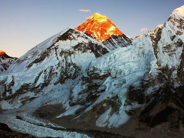
The summit of Everest rises behind the Lhotse-Nuptse wall, the view that draws trekkers to this route.
In this guide: At a glance | Altitude profile | Day-by-day itinerary | Permits | Best season | Packing and tips | FAQ
Everest Base Camp trek at a glance
| Region | Khumbu, inside Sagarmatha National Park |
| Base Camp | 5,364 m / 17,598 ft |
| Highest viewpoint | Kala Patthar, 5,545 m / 18,192 ft |
| Highest sleeping altitude | Gorak Shep, 5,180 m / 16,994 ft |
| Length | 14 days, with 9 walking days |
| Walking | About 106 to 112 km and 50 to 58 hours in total |
| Rest days | 2 (Namche Bazaar and Dingboche) |
| Lodging | Teahouses on the trail, hotel in Kathmandu |
| Difficulty | Strenuous, no technical climbing |
Altitude profile: where you sleep
Sleeping altitudes on the 14-day schedule. The two blue bars are the rest days.
| Night | Sleeping altitude | Profile |
|---|---|---|
| Day 2 Phakding | 2,652 m / 8,701 ft |
|
| Day 3 Namche Bazaar | 3,440 m / 11,286 ft |
|
| Day 4 Namche Bazaar (rest) | 3,440 m / 11,286 ft |
|
| Day 5 Deboche | 3,700 m / 12,139 ft |
|
| Day 6 Dingboche | 4,400 m / 14,436 ft |
|
| Day 7 Dingboche (rest) | 4,400 m / 14,436 ft |
|
| Day 8 Lobuche | 4,900 m / 16,076 ft |
|
| Day 9 Gorak Shep | 5,180 m / 16,995 ft |
|
| Day 10 Pheriche | 4,320 m / 14,173 ft |
|
| Day 11 Namche Bazaar | 3,440 m / 11,286 ft |
|
| Day 12 Lukla | 2,800 m / 9,186 ft |
|
The Nepal Tourism Board (NTB) advises that above 2,500 m sleeping altitude should rise by no more than 300 to 500 m a day, with a rest day after every 1,000 m gained. Most nights on this schedule stay within that range. Two steps are larger, Phakding to Namche Bazaar (about 790 m) and Deboche to Dingboche (about 700 m), and each is followed by a rest day. Read the acclimatisation guide for the reasoning.
Day-by-day itinerary
All distances and times are approximate. Trail conditions and lodge availability can change the route slightly.
Day 1: Arrive in Kathmandu
| Altitude | 1,350 m / 4,428 ft |
| Overnight | Kathmandu hotel |
A team member meets you at the airport and takes you to your hotel. In the evening the team briefs you on the route, checks your gear and answers last questions. Rent a sleeping bag or down jacket now if you need one, then sleep early, because Day 2 starts in the middle of the night.
Day 2: Fly to Lukla and walk to Phakding
| Altitude | Lukla 2,800 m / 9,184 ft, Phakding 2,652 m / 8,698 ft |
| Travel | Drive of about 5 to 6 hours to Ramechhap, then a 15-minute flight to Lukla |
| Walking | 8 km, 3 to 4 hours |
| Overnight | Phakding |
Please read: Lukla flights currently operate from and back to Ramechhap, not Kathmandu. The team leaves Kathmandu at about 2 am for the drive, and the drive back at the end takes 5 to 6 hours depending on traffic. See the Lukla vs Ramechhap guide.

Lukla airstrip, where the walk begins.
A short morning flight lands in Lukla, where you meet your guide and porter. The first walk is easy: through Chaurikharka village, then down to Dudhkoshi Ghat at 2,530 m, and on beside the Dudh Koshi river to Phakding. The modest altitude lets the body start adapting, and the afternoon is free to look around.
Day 3: Phakding to Namche Bazaar
| Altitude | 3,440 m / 11,283 ft |
| Walking | 10 to 12 km, 5 to 6 hours |
| Overnight | Namche Bazaar |

The trail above Phakding crosses the river on long suspension bridges.
After breakfast the trail crosses the Dudh Koshi on a long suspension bridge and runs through pine forest to Monjo, about two hours on. Just beyond is the entrance to Sagarmatha National Park, where your permit is checked. The path passes mani stones to Jorsale for lunch, then climbs steadily to Namche Bazaar, with two river crossings, one on the high Hillary Suspension Bridge. The last hill is hard, and it ends in Namche, the main Sherpa trading town of the Khumbu, with a first view of Everest on the way.
Day 4: Rest and acclimatisation at Namche Bazaar
| Altitude | 3,440 m / 11,283 ft |
| Optional walk | About 2 hours uphill to the Everest View Point |
| Overnight | Namche Bazaar |
Today is a rest day. For gentle exercise, walk uphill for about two hours to the Everest View Point, which helps acclimatisation and shows the big peaks. Back in town, visit the Sherpa museum for Sherpa culture and the history of climbing in the region, browse the shops that sell and rent trekking gear and, on Saturdays, see the Hatt Bazaar, the weekly local market. Buy anything you need now, because the higher you go, the less there is to buy.
Day 5: Namche Bazaar to Deboche (Melingo)
| Altitude | 3,700 m / 12,139 ft |
| Walking | 10 km, about 6 hours |
| Overnight | Deboche or Melingo |

The trail from Namche opens up views of Everest, Lhotse and Ama Dablam.
From Namche the trail turns toward Base Camp, and the views are among the best of the trek: Everest, Nuptse, Lhotse, Ama Dablam, Thamserku and Kwangde. Phortse sits on the opposite side of the valley and is another viewpoint for Ama Dablam.
Day 6: Deboche to Dingboche
| Altitude | 4,400 m / 14,435 ft |
| Walking | 11 km, about 6 hours |
| Overnight | Dingboche |

Prayer wheels line the trail through the Sherpa villages.
The trail follows the Imja Khola, a glacial-blue river in a deep canyon. A gradual climb leads to Pangboche, the largest Sherpa settlement in the region, where you can see village life and have lunch. Walk up to Pangboche monastery if you have energy, because it is one of the oldest in the area. The afternoon is harder, as the landscape turns dry and bare on the climb to Dingboche.
Route note: depending on conditions and lodge space, the team may use the trail on the other side of the river through Phortse. It leaves the main route after Namche on Day 5 and runs parallel to the Deboche trail, and the two join again at Pangboche.
Day 7: Rest and acclimatisation at Dingboche
| Altitude | 4,400 m / 14,435 ft |
| Optional walk | Toward Chhukung and the Imja valley |
| Overnight | Dingboche |
This is the last full rest day before the final climb. Spend it around Dingboche, or take an easy walk toward Chhukung and the Imja valley, which leads to Island Peak, the high Amphu Laptsa pass and Makalu Barun National Park. The views reward a short walk, but the main aim is rest, because the next days are demanding.
Day 8: Dingboche to Lobuche
| Altitude | 4,900 m / 16,076 ft |
| Walking | 11 to 12 km, 6 to 7 hours |
| Overnight | Lobuche |

Memorial stupas above Dughla honour climbers and trekkers who died on Everest.
The climbing eases, but the altitude makes every step heavier. After Dughla, a steep climb to a ridge top leads to memorial stupas for the climbers and trekkers who have died on Everest. The path then crosses rocky terrain to Lobuche, a small settlement with views of Lobuche peak, Pumori and Nuptse. At this height nights are cold, so layer up.
Day 9: Lobuche to Gorak Shep and Everest Base Camp
| Altitude | Gorak Shep 5,180 m / 16,994 ft, Everest Base Camp 5,364 m / 17,598 ft |
| Walking | 15 km, 6 to 8 hours |
| Overnight | Gorak Shep |

Everest Base Camp, where the climbing route to the summit begins.
This is the day the trek is built around. The walk from Lobuche to Gorak Shep is fairly easy. The trail to Base Camp is harder, crossing rocky ridges and moraine, the loose debris left by glaciers, and passing the Khumbu Glacier and the Icefall on the slopes of Everest. The ground is uneven and shifting, so stay close to your guide. In the spring climbing season you may meet expedition climbers at Base Camp. Take your photographs, then return to Gorak Shep in the afternoon to rest. Altitude symptoms most often show up around now, so tell your guide at once if you feel unwell.
Day 10: Kala Patthar, then down to Pheriche
| Altitude | Kala Patthar 5,545 m / 18,192 ft, Pheriche 4,320 m / 14,173 ft |
| Walking | 12 to 13 km, 5 to 6 hours |
| Overnight | Pheriche (or Pangboche if the group has energy) |

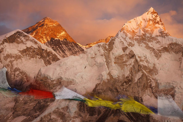
Sunrise from Kala Patthar, the best view of Everest on the trek.
You rise before dawn and climb Kala Patthar, the “black rock”, for sunrise. First light touches Nuptse, Changtse and Lhotse, and this is probably the best moment of the trek for photographs of Everest and its neighbours. You return to Gorak Shep for breakfast and then head down toward Pheriche for the night, or on to Pangboche if the group has the energy. The descent is brisker and easier on the legs.
Day 11: Pheriche to Namche Bazaar
| Altitude | 3,440 m / 11,283 ft |
| Walking | 13 to 15 km, 7 to 8 hours |
| Overnight | Namche Bazaar |

Namche Bazaar again, now in the thicker air of the lower valley.
The walk back through Pangboche and Tengboche is mostly downhill, apart from one climb of about an hour. You reach Namche in the late afternoon and rest before the final day of walking.
Day 12: Namche Bazaar to Lukla
| Altitude | 2,800 m / 9,184 ft |
| Walking | 16 km, 6 to 7 hours |
| Overnight | Lukla |
After breakfast the walk returns over the Hillary Suspension Bridge and through several villages to Lukla. Many trekkers find this day hard on the knees, and trekking poles help on the long descent. Tonight is your last teahouse night, and by tradition the trekking crew celebrates with you.
Day 13: Lukla to Kathmandu
| Altitude | 1,350 m / 4,428 ft |
| Flight | 35 minutes to Kathmandu, or 15 minutes to Ramechhap |
| Overnight | Kathmandu hotel |

Boudhanath stupa in Kathmandu, a gentle place for the day after the flight.
A short morning flight takes you out of the mountains, and you transfer to your hotel to rest. In the evening the team hosts a farewell dinner at one of Kathmandu’s Nepali restaurants and asks for your feedback. Because the flight lands at Ramechhap on current arrangements, allow the 5 to 6 hour drive on to Kathmandu. See what to do with free days in the Kathmandu spare-days guide.
Day 14: Departure from Kathmandu
| Altitude | 1,350 m / 4,428 ft |
Have breakfast and do some last shopping. The team takes you to Tribhuvan International Airport in good time for your flight home, and the service ends there. Keep at least one spare day before your international flight, because Lukla flights are weather-dependent. The Lukla delay plan explains what to do if the flight is held.
Permits and fees
The package includes the permits. They are listed here for reference, as published by NTB, whose pages carry no update date, so confirm current fees.
| Permit | Fee |
|---|---|
| Sagarmatha National Park entry, foreigners | NPR 3,000 per entry |
| Sagarmatha National Park entry, SAARC nationals | NPR 1,500 per entry |
| Khumbu Pasang Lhamu local permit | US$20 per person per week for the first four weeks |
| TIMS card | US$10 equivalent for group trekkers and US$20 for free individual trekkers |
Children under 10 enter Sagarmatha National Park free. For a full cost breakdown, see the cost guide for Indian trekkers.
Best time to trek
The main trekking seasons are spring, from March to May, and autumn, from September to November, when skies are clearer and the trail is busiest. December to February is colder but possible. June to August is the monsoon, and the team generally does not recommend trekking then. In spring you may meet climbing expeditions at Base Camp. Read the best time guide for month-by-month detail.
Packing, cash and practical tips
- Socks and boots. Bring several pairs of socks, and wear boots that are already broken in. New boots cause blisters that can spoil the trek.
- Rent in Kathmandu. A sleeping bag and down jacket can be rented at a reasonable price. See the packing list.
- Food. The team recommends vegetarian meals in the mountains, where meat is carried up slowly and kept for days.
- Flights. Book a changeable return flight, and keep spare days, because Lukla weather is unreliable.
- Cash. Carry Nepali rupees. The site suggests Rs 25,000 to 40,000 for extras, tips and emergencies, because cards and machines are unreliable above Lukla.
- Tips. Tipping is appreciated and not compulsory. The site’s guideline is US$50 to 75 for the team. See the tipping guide.
- Altitude. Stick to the schedule and do not push to the limit. Tell your guide about any symptoms. See the altitude sickness guide.
- Accommodation. Rooms become more basic as you climb. Keep an open mind and enjoy the view and the culture.
- Training. Build up long walks before you go. See the training guide.
FAQ
How many days is the Everest Base Camp trek? The schedule here is 14 days from arrival in Kathmandu to departure, with 9 walking days and two rest days.
How high is Everest Base Camp? Base Camp is at 5,364 m (17,598 ft). Kala Patthar, the viewpoint, is at 5,545 m (18,192 ft), and the highest sleeping altitude is Gorak Shep at 5,180 m.
How far do you walk each day? Walking days run from 8 km on Day 2 to 16 km on Day 12, taking 3 to 8 hours. The total is about 106 to 112 km.
Where do the flights to Lukla leave from? Currently from Ramechhap, about a 5 to 6 hour drive from Kathmandu, with a 15-minute flight. The return flight lands there too. Confirm the arrangement for your dates.
Where are the rest days? At Namche Bazaar on Day 4 and Dingboche on Day 7. They follow the NTB rule of a rest day after every 1,000 m gained.
Which permits do I need? The park entry, the Khumbu local permit and a TIMS card, all included in the package. NTB lists the park at NPR 3,000 for foreigners and NPR 1,500 for SAARC nationals.
What is the best time to go? March to May and September to November. December to February is colder, and June to August is the monsoon.
Is the trek hard? It is strenuous but not technical. Altitude is the main challenge, so the rest days and a steady pace matter more than fitness alone.
When is the first view of Everest? On the way up to Namche Bazaar on Day 3, and then much more clearly from Day 5 onward.
What is the hardest day? Many trekkers find Day 9, the 15 km walk to Base Camp at altitude, the hardest, and Day 12, the long descent, hard on the knees.
How much cash should I carry? The site suggests Rs 25,000 to 40,000 for extras, tips and emergencies, in Nepali rupees.
Is travel insurance needed? Yes. It is mandatory and must cover high-altitude trekking and helicopter evacuation. See the insurance guide.
Can I fly down instead of walking? A planned helicopter return from Gorak Shep to Lukla is available on some itineraries and saves about two days. See the helicopter return guide.
Book the 14-day trek
For dates and a quote, see the 14-day Everest Base Camp trek, message the team on WhatsApp or phone at +91 932 595 1234 (9 am to 7 pm IST), write to info@basecamphikes.com, or use the enquiry form. First-timers can start with the first-time trekker’s guide.
Sources
- Nepal Tourism Board: Everest Base Camp
- Nepal Tourism Board: safety in the mountains
- Nepal Tourism Board: park entry fees
- Nepal Tourism Board: trekking permit
- Nepal Tourism Board: FAQ